
Auckland
At
17°C
- Sunrise:
- Sunset:
Cloudy periods with areas of morning fog. Northeasterlies developing this afternoon.
Cloudy periods. A few showers, mainly in the evening. Northerlies, becoming strong in the afternoon.
A period of rain with heavy falls in the morning, otherwise a few showers. Strong northerlies, easing in the afternoon.
For more detailed weather information visit MetService.
Marine Recreational Forecasts - Auckland
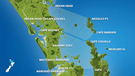
Area Description:
Bream Head to Cape Colville, Hauraki Gulf, Waitematā Harbour, Manukau Harbour
Situation:
A weak ridge moves away from the upper North Island today, with a series of troughs moving on in a strengthening northerly flow tomorrow. Meanwhile a frontal system embedded in a northerly flow moves up the west coast of the South Island today and on to central New Zealand tomorrow. On Friday the front moves east across the North Island while the low deepens and moves onto central New Zealand. On Saturday a cold southwesterly flow develops over the country as the low moves away to the east. On Sunday, a narrow ridge moves onto the country, followed by a front in the far south by the end of the day.
Warnings:
Strong wind advisory Strong wind advisory Strong wind advisory
Forecasts:
For Bream Head to Cape Colville: Today: Northerly 15 knots, rising to 20 knots this evening. Sea becoming moderate this evening. Fine spells. Chance evening shower. Northeast swell half a metre. For Hauraki Gulf: Today: Northeast 10 knots rising to northerly 15 knots around midday, and to 20 knots this evening. Sea becoming moderate this evening. Fine spells. Chance evening shower. For Waitematā Harbour: Today: Northeast 10 knots, rising to northerly 15 knots this afternoon, then to 20 knots late evening. Sea becoming moderate late evening. Fine spells. Chance evening shower. For Manukau Harbour: Today: Northeast 10 knots, rising to northerly 15 knots this afternoon. Sea slight but choppy when wind opposes tide. Fine spells. For the west coast: Southwest swell 2 metres, easing to 1 metre.
Outlook:
For Bream Head to Cape Colville: Thursday: Northerly 20 knots, rising to 25 knots gusting 35 knots early morning, and to 30 knots gusting 40 knots in the evening. Sea becoming rough early morning. Fair visibility in showers developing in the evening. Northeast swell half a metre, rising to 2 metres. Friday: Northerly 30 knots. Rain, easing. Northeast swell 2 metres. Saturday: Northwest 25 knots, easing to westerly 15 knots late. A few showers developing. Northerly swell 2 metres easing. Sunday: Southwest 20 knots, easing to 10 knots late. Fine. Northeast swell 1 metre. For Hauraki Gulf: Thursday: Northerly 20 knots rising to 25 knots gusting 35 knots in the morning, and to 30 knots gusting 40 knots late evening. Sea becoming rough in the morning. Fair visibility in showers developing in the evening. Northerly swell 1 metre developing. Friday: Northerly 30 knots. Rain, clearing. Northerly swell 1 metre. Saturday: Northwest 25 knots, easing to westerly 15 knots later. A few showers. Northerly swell 1 metre dying out. Sunday: Southwest 20 knots, easing to 10 knots late. A few showers. For Waitematā Harbour: Thursday: Northerly 20 knots, rising to 25 knots gusting 30 knots late morning. Sea becoming rough late morning. Fair visibility in showers developing in the evening. Friday: Northerly 25 knots. Rain, clearing. Saturday: Northerly 20 knots, becoming westerly 20 knots early. A few showers. Sunday: Southwest 15 knots. A few showers. For Manukau Harbour: Thursday: Northerly 15 knots rising to 20 knots in the morning. Sea becoming moderate in the morning but choppy when wind opposes tide. Fair visibility in showers developing in the evening. For the west coast: Westerly swell 1 metre, rising to 2 metres. Friday: Northerly 20 knots. Rain, clearing. For the west coast: Westerly swell rising to 3 metres. Saturday: Northerly 15 knots, becoming westerly 15 knots early. Showers, clearing. For the west coast: Westerly swell 3 metres. Sunday: Southwest 15 knots. A few showers. For the west coast: Westerly swell 3 metres easing.
Swell:
Marine Coastal Forecasts - Colville
Forecast:
Wednesday: Northeast rising to 20 knots in the afternoon. Sea becoming moderate. Northeast swell 1 metre developing.
Outlook:
Outlook following 3 days: Thursday: Northerly 20 knots gradually rising to 30 knots by evening. Sea becoming rough. Northeast swell rising to 2 metres. Fair visibility in showers. Friday: Northerly 30 knots. Sea rough. Northerly swell becoming heavy. Saturday: Northwest 25 knots. Sea rough. Heavy northerly swell easing. Sunday: Westerly 20 knots. Moderate northeast swell.
Marine Coastal Forecasts - Raglan
Forecast:
Wednesday: Northerly 25 knots. Sea rough. Long period southwest swell 2 metres, easing. Northwest swell 1 metre developing. Fair visibility in a few evening showers.
Outlook:
Outlook following 3 days: Thursday: Northerly 25 knots rising to 35 knots in the afternoon. Sea becoming very rough. Northwest swell rising to 3 metres offshore. Southwest swell 1 metre. Fair visibility in showers, mainly in the evening. Friday: Northerly 35 knots, easing to 25 knots in the afternoon. Very rough sea easing. Moderate northwest swell. Saturday: Northwest 25 knots, turning southwest 25 knots early. Sea rough. Westerly swell becoming heavy for a time. Sunday: Southwest 20 knots. Moderate southwest swell.